
-
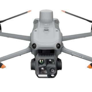
Drone matrice 4t eu/cp.en.00000545 dji
Introducing the DJI Matrice 4 Series, a new compact and intelligent multi-sensor flagship drone series for enterprise industries. The series includes Matrice 4T and Matrice 4E, each equipped with advanced features such as smart detection and measurement with laser range finder. Flight operations are now safer and more reliable with significantly enhanced sensing capabilities. The accessories for the Matrice 4 series have also been significantly upgraded. The Matrice 4T is suitable for a wide range of industries, including electricity, emergency response, public safety, and forestry conservation. The Matrice 4E is designed for geospatial applications such as surveying and mapping, construction, and mining. A new era in intelligent aerial operations begins now.
Two Models, Countless Applications
Intelligent Operations
Smarter Operations
The built-in model can detect vehicles, vessels, and subjects during search and rescue operations or routine flights. It also supports switching to other models, enabling the expansion of application scenarios. Additionally, it supports high-res grid photos and features powerful tracking capabilities.Laser Range Finder, Precise Measurement
The laser range finder enables real-time precise measurement. Through simple operations such as pin point, line drawing, and area calculation, it can complete tasks like marking target locations for inspection purposes or calculating the area of a wildfire. Additionally, users can share info via the DJI Pilot QR code or FlightHub 2 with relevant personnel to enhance collaboration and workflow efficiency.Observation Range Recording
DJI Pilot 2 can highlight the center position of the camera frame and ground area observed. It can display the surveyed area on the map, making it especially useful for patrols, and rescue operations in mountainous terrain without clear landmarks.Efficient Flight, Intelligent Operations
Cruise
Activate cruise control mode to pilot the drone in a specific direction without constantly pressing the control sticks, making long-distance flights easier.FlyTo
In emergencies or disasters, the drone can automatically adjust its flight path and speed based on the surrounding environment, allowing it to reach a designated location without manual adjustments.Smart Track
Smart Track allows for precise subject positioning and automatic zoom adjustments, allowing you to switch between subjects easily. It can automatically reacquire a subject even if obscured briefly.POI
POI enables continuous observation and 3D modeling of buildings while flying around a designated area, greatly enhancing the efficiency of fixed-point observation and modeling tasks.Excel In Low-Light Environments
Night Scene Mode
The Matrice 4 series has received a significant night mode upgrade. Its Full-Color night vision now supports three modes and includes two levels of enhanced noise reduction. Equipped with an IR Cut Filter and NIR auxiliary light, it effortlessly overcomes the challenges of darkness, ensuring search and rescue subjects clearly visible.Smart Low-Light Photo
Smart Low-Light Photo
The Matrice 4 series cameras feature larger apertures and intelligent low-light capabilities, significantly enhancing performance and improving operations during dusk and nighttime.NIR Auxiliary Light
NIR Auxiliary Light
The Matrice 4T features new NIR illumination hardware, enabling lighting distances of up to 100 meters. This ensures clear visibility of objects in dark environments, making it ideal for applications like wildlife protection.Thermal Imaging
Thermal Imaging
The Matrice 4T supports infrared High-Res Mode, with image resolutions up to 1280 × 1024. It also offers Ultra-High Resolution, revealing small temperature details for various operations. Each device undergoes temperature accuracy calibration and utilizes an onboard temperature sensor to provide real-time temperature measurements.Low-Light Fisheye Omnidirectional Sensing
Low-Light Fisheye Omnidirectional Sensing
The Matrice 4 series has six high-definition low-light fisheye vision sensors, significantly enhancing visual low-light positioning and obstacle avoidance capabilities. This allows for automatic obstacle avoidance, intelligent rerouting, and safe return in urban low-light environments.Crystal Clear Vision: Unveil the Details
Capture Every Detail at A Distance
Enhanced Medium Telephoto
The Matrice 4 series is equipped with a medium tele camera, expanding its capabilities for medium-range inspection tasks. During power line or bridge inspections, it can detect screws and cracks from a distance of 10 meters and clearly read instrument data at substations.Super Resolution Telephoto
The tele camera of the Matrice 4 series has significantly improved clarity, featuring 48 MP resolution, capable of capturing incredibly details from signs up to 250 meters away. Additionally, the Matrice 4T is equipped with an IR-Cut Filter, ensuring 24/7 operations.Foreground Stabilization for Telephoto Imagery
The upgraded telephoto stabilization makes foreground subjects stable and clear during telephoto shooting at 10x zoom or higher. In scenarios such as public safety and inspections, subject details are clearly visible.Electronic Dehazing, Clear as Ever
In conditions such as smog or atmospheric humidity, Electronic Dehazing supports three modes (Low, Medium, High) to improve the imaging clarity of the Matrice 4 series to match different operational environments and requirements.Precision Mapping, Time-Saving and Effortless
Rapid 0.5-Second Interval Shooting
The Matrice 4E wide-angle camera supports rapid 0.5-second interval shooting in both orthophoto and oblique photography modes, enabling high-speed aerial surveying from multiple angles. Additionally, the mapping flight speed can reach up to 21 meters per second, significantly enhancing work efficiency.Multi-Directional Capture, Efficiency Multiplied
5-Directional Oblique Capture
The Matrice 4 series supports a new 5-directional oblique capture. The gimbal can intelligently rotate and shoot at multiple angles based on the survey area, achieving the effect of multiple shots in a single flight compared to previous models, significantly enhancing the efficiency of small drone oblique photography.3-Directional Ortho Capture [10]
Matrice 4E supports 3-directional ortho capture, enabling lateral capturing while performing ortho collection tasks, which reduces lateral overlap. A single flight can complete mapping operations for an area of 2.8 square kilometers. No additional elevation optimization flight route is required to achieve better elevation accuracy. Combined with new DJI Terra capabilities, it further enhances reconstruction efficiency while ensuring quality.Smart 3D Capture, Precision Modeling
DJI Matrice 4E supports Smart 3D Capture, which allows you to capture and create a rough model on the remote controller. Based on the rough model, it can quickly generate precise mapping routes close to a structures surface, completing detailed measurements and modeling of irregular buildings. It also supports displaying virtual space routes and waypoint photos for smart 3D capture, making it convenient to assess specific routes' flight safety and coverage area.Distortion Correction, Precision Enhancement
Distortion Correction, Precision Enhancement
Distortion Correction 2.0 provides high-precision in-camera distortion correction with residual distortion less than 2 pixels. Each Matrice 4E's wide-angle camera is calibrated before leaving the factory, when used with DJI Terra, it significantly improves reconstruction accuracy.Auto-Generated Surveying Operation Report
Auto-Generated Surveying Operation Report
Upon completion of an operation, DJI Pilot 2 can automatically generate a survey quality report. This report provides comprehensive access to key information such as photo points, RTK status, and photo parameters. If there are any anomalies, additional photos can be taken on-site to avoid repeated trips.Safe Flight, Worry-Free Operation
Fusion Positioning, Safe Return-to-Home
The Matrice 4 series comes with an integrated DJI RTK module which supports the extended L5 frequency band and features GNSS+Vision Fusion Positioning and Navigation System. It allows for the return-to-home point to be updated through visual positioning, allowing for rapid takeoff within 15 seconds. Even without GNSS signals, it can complete the return-to-home process, effectively overcoming signal obstructions and interference commonly found in urban environments.Intelligent Guidance, Unobstructed Flight
When the DJI RC Plus 2 Enterprise remote controller is connected to the internet, it can load terrain elevation maps and preload detailed maps. This enables automatic path planning for obstacle avoidance, effectively managing scenarios such as flying at night or through mountainous areas, ensuring the safety of flight operations. The drone has a 5-directional vision assist view system along with downward vision, which aids in providing comprehensive visibility for enhanced protection.Achieve New Heights in Video Transmission
The O4 Enterprise video transmission system sets a new industry standard for challenging environments. Thanks to the 8-antenna system in the Matrice 4 Series and the high-gain antenna in the remote controller, you can achieve up to 25 kilometers in transmission range. Furthermore, the system improves image transmission with a download bandwidth of 20MB/s, more than double the bitrate of the Mavic 3 Enterprise Series, ensuring more precise and stable images of route uploads and material downloads.The Matrice 4 series supports an optional DJI Cellular Dongle 2. By utilizing 4G image transmission in conjunction with the aircraft's antennas, signal stability is further enhanced.
Accessory Upgrades, Performance Leap
Gimbal-Following Spotlight
The DJI AL1 SpotLight can illuminate subjects up to 100 meters away, and features two modes, Always-On and Strobe. It can connect with the gimbal, enabling it to follow the camera's movements to ensure the illuminated area aligns with the camera's view. Additionally, the spotlights can focus on a single object or offer a wide field of view (FOV) which illuminates up larger areas.Real-Time Voice Speaker
The DJI AS1 Speaker offers impressive sound power and extensive range. It has a broadcast range of up to 300 meters and can produce a volume of up to 114 decibels at a distance of 1 meter. It supports recorded messages, media imports, and text-to-speech conversion. Additionally, it features real-time broadcasting and echo suppression, enhancing the efficiency and flexibility of emergency search-and-rescue operations.Integrated Broadcasting and Lighting
The spotlight and speaker can function independently or together, addressing various operational scenarios.High-Precision D-RTK 3 Multifunctional Station
The D-RTK 3 Multifunctional Station can serve as a base station to provide centimeter-level positioning for multiple drones simultaneously or extend the operational range of drones in relay station mode*. Additionally, the new Rover Station Mode, combined with the DJI Enterprise app and DJI Terra, provides a comprehensive solution for high-precision aerial surveying applications, ensuring a secure and accurate operation.DJI RC Plus 2 Enterprise
DJI RC Plus 2 Enterprise remote controller features a new high-brightness screen that remains clearly visible even in direct sunlight. It has an IP54 protection rating and can operate in temperatures ranging from -4°F to 122°F (-20°C to 50°C). Using the O4 Enterprise video transmission system, it features a built-in high-gain antenna array, providing strong performance. It also supports O4 Enterprise and 4G hybrid transmission solutions, ensuring stable and smooth video transmission in urban high-rise areas and mountainous environments.DJI Cellular Dongle 2 [14]
The DJI Cellular Dongle 2 offers 4G network video transmission and can work together with the O4 Enterprise video transmission system, ensuring safe flights in complex environments. Additionally, it provides mobile network connectivity for the remote controller.DJI Power 1000
DJI Power 1000 can provide up to 200W fast charging for Matrice 4 Series intelligent batteries, fully charging one battery in 48 minutes. It also offers 2200W AC output, ensuring a reliable and stable power supply for outdoor operations. Additionally, it can be paired with the DJI Power 1kW car charger, allowing for 1kW fast charging, supporting outdoor operations with continuous power and uninterrupted journeys.Software Designed for Industries
DJI Pilot 2
DJI Pilot 2 interface has been comprehensively updated, featuring a customizable intelligent function toolbar and support for various types of flight routes. Additionally, it includes virtual space models and route preview functions, making operations more convenient and efficient. It can connect with FlightHub 2 to enhance drone control operations and facilitate cloud information sharing, therefor reducing the workload of frontline pilots.DJI FlightHub 2
Specifically for the Matrice 4 series aircraft, DJI FlightHub 2 has been upgraded for remote control, allowing a variety of flight route planning functions, including remote takeoff and landing, Smart 3D Capture routes, geometric routes, and slope routes. Operators can control both the payload and the aircraft simultaneously through Live Flight Controls features. During multi-drone operations, operators can synchronize multiple livestreams on a single screen, creating a new efficient air-ground operation experience.DJI Terra
DJI Terra enables high-precision camera distortion correction for the Matrice 4E. It supports free offline PPK processing of visible light images and allows for importing D-RTK 3 data, which enhances reconstruction accuracy. The software provides rich 2D, 3D, and point cloud model data, catering to various applications such as geographic information, emergency response, and construction planning.DJI Modify
DJI Modify provides intelligent 3D mesh and point cloud model editing. When paired with the Matrice 4 Series and DJI Terra, it can create an integrated solution covering aerial surveying, modeling, model repair, and sharing.DTAT 3.0
After completing thermal imaging operations with Matrice 4T, you can use the DTAT 3.0 thermal analysis tool to mark, analyze, and process images, detecting abnormal temperature points.Open Developer Ecosystem
Intelligent Algorithm Developer
Provides the necessary model training tools and third-party developer certification process to access onboard computing capability, helping expand new drone intelligent algorithm application fields.PSDK
E-Port and E-Port Lite encryption authentication ensure secure and worry-free payloads, enabling the Matrice 4 Series to have broader application scenarios.MSDK
Mobile SDK 5 simplifies the development of apps to control the Matrice 4 Series. Mobile SDK 5 is fully open source and comes with production code samples of core DJI Pilot 2 modules, ensuring its reliability.Cloud API
With DJI Pilot 2's built-in Cloud API (MQTT-based protocol) you can directly connect the Matrice 4 Series to third-party cloud platforms. Access the drone's hardware, video live-stream, and photo data without having to develop an app.DJI Terra API
With the DJI Terra API, users can integrate its powerful mapping capabilities into their own platforms, achieving automated 2D and 3D reconstructions. Additionally, users can customize photogrammetry workflows as needed, allowing the Matrice 4E's operational results to meet the needs of various industry applications better.User Data Security
Get 1 Year of DJI Care Enterprise Plus or 1 Year of Official Extended Warranty Service for Free
DJI Care Enterprise Plus
Comprehensive Protection | Professional Quality Assurance | Exclusive Service | Service Starts with ActivationFree Repairs
Unlimited number of free repairs within the coverage limit.Flyaway Coverage
1 time/year, worry-free operationCoverage for Your Whole Fleet
Shared limit for maximum protectionFree Shipping
Free Mail-in Repairs, Hassle-Free ServiceExtended Warranty Service
During the service period, the main parts remain covered by the official warranty, bringing longer protection for your product. -
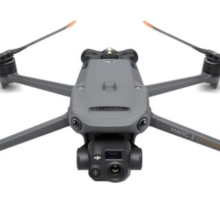
Drone mavic 3 thermal eu/cp.en.00000499 dji
The Mavic 3 Enterprise Series redefines industry standards for small commercial drones. With a mechanical shutter, a 56× zoom camera, and an RTK module for centimeter-level precision, the Mavic 3E brings mapping and mission efficiency to new heights. A thermal version is available for firefighting, search and rescue, inspection, and night operations.
Compact and Portable
Streamlined and compact, Mavic 3 Enterprise Series can be carried in one hand and deployed at a moment's notice. Perfect for beginner and veteran pilots alike, it's built to perform on lengthy missions.Survey with Speed
Mavic 3E's wide-angle 4/3 CMOS, 20MP sensor has a mechanical shutter to prevent motion blur and supports rapid 0.7-second interval shooting. Complete mapping missions with extraordinary efficiency without the need for Ground Control Points.Improved Low-Light Performance
Mavic 3E's Wide camera has large 3.3μm pixels that, together with intelligent low-light mode, offer significantly improved performance in dim conditions.Focus and Find
Both Mavic 3E and Mavic 3T are equipped with a 12MP Zoom Camera, supporting up to 56× Max Hybrid Zoom to see essential details from afar.See the Unseen
Mavic 3T's thermal camera has 640 × 512 resolution and supports point and area temperature measurement, high temperature alerts, color palettes, and isotherms to help you find your targets and make quick decisions.Simultaneous Split-Screen Zoom
Mavic 3T's thermal and zoom cameras support 28× continuous side-by-side zoom for easy comparisons.Exceptional Operational Efficiency
45-min flight durations let you cover more ground each mission, for surveying of up to 2 square kilometers in a single flight.Next-Generation Image Transmission
Quad-antenna O3 Enterprise Transmission enables more stable connections in a wide variety of complex environments.Omnidirectional Sensing for Safe Flying
Equipped with wide-angle lenses on all sides for omnidirectional obstacle avoidance with zero blind spots. Adjust proximity alarms and braking distance depending on mission requirements.Advanced RTH automatically plans the optimal route home, saving power, time, and hassle.
APAS 5.0 enables automatic rerouting around obstacles, so you can fly with peace of mind. [7]
DJI RC Pro Enterprise
A portable remote controller with a 1,000-nit high-brightness screen for clear visibility in direct sunlight, a built-in microphone for clear communication, and 1.5-hour 65W fast charging.Full Software Suite
A revamped Enterprise flight interface designed to improve piloting efficiency and flight safety. Drone and payload controls can be easily accessed with one tap. Clear presentation of flight details and navigational information improves user experience together with support for various route types.DJI FlightHub 2
All-in-one cloud drone operations management for your fleet with support for live annotations and cloud mapping for seamless ground-to-cloud synergy. Efficiently manage inspection operations with route planning and mission management.DJI Terra
Full featured mapping software for all stages of work, from mission planning to processing of 2D and 3D models.DJI Thermal Analysis Tool 3.0
Analyze, annotate, and process images captured by M3T using DTAT 3.0 to detect temperature abnormalities in your inspections.PSDK
PSDK is a unified interface that enables expansion of Mavic 3 Enterprise Series capabilities through third-party hardware.MSDK
Mobile SDK 5 simplifies the development of apps to control the Mavic 3 Enterprise Series. Mobile SDK 5 is fully open source and comes with production code samples of core DJI Pilot 2 modules.Cloud API
With Pilot 2's built-in MQTT based protocols in DJI Cloud API, you can directly connect the Mavic 3 Enterprise Series to Third-Party cloud platforms without having to develop an App. Access the drone's hardware, video live-stream, and photo data.
-
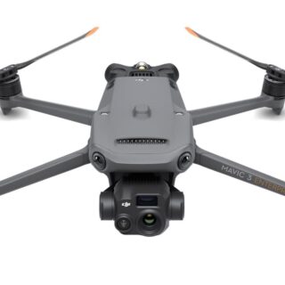
Drone mavic 3 thermal univer./cp.en.00000415 dji
The Mavic 3 Enterprise Series redefines industry standards for small commercial drones. With a mechanical shutter, a 56× zoom camera, and an RTK module for centimeter-level precision, the Mavic 3E brings mapping and mission efficiency to new heights. A thermal version is available for firefighting, search and rescue, inspection, and night operations.
Compact and Portable
Streamlined and compact, Mavic 3 Enterprise Series can be carried in one hand and deployed at a moment's notice. Perfect for beginner and veteran pilots alike, it's built to perform on lengthy missions.Survey with Speed
Mavic 3E's wide-angle 4/3 CMOS, 20MP sensor has a mechanical shutter to prevent motion blur and supports rapid 0.7-second interval shooting. Complete mapping missions with extraordinary efficiency without the need for Ground Control Points.Improved Low-Light Performance
Mavic 3E's Wide camera has large 3.3μm pixels that, together with intelligent low-light mode, offer significantly improved performance in dim conditions.Focus and Find
Both Mavic 3E and Mavic 3T are equipped with a 12MP Zoom Camera, supporting up to 56× Max Hybrid Zoom to see essential details from afar.See the Unseen
Mavic 3T's thermal camera has 640 × 512 resolution and supports point and area temperature measurement, high temperature alerts, color palettes, and isotherms to help you find your targets and make quick decisions.Simultaneous Split-Screen Zoom
Mavic 3T's thermal and zoom cameras support 28× continuous side-by-side zoom for easy comparisons.Exceptional Operational Efficiency
45-min flight durations let you cover more ground each mission, for surveying of up to 2 square kilometers in a single flight.Next-Generation Image Transmission
Quad-antenna O3 Enterprise Transmission enables more stable connections in a wide variety of complex environments.Omnidirectional Sensing for Safe Flying
Equipped with wide-angle lenses on all sides for omnidirectional obstacle avoidance with zero blind spots. Adjust proximity alarms and braking distance depending on mission requirements.Advanced RTH automatically plans the optimal route home, saving power, time, and hassle.
APAS 5.0 enables automatic rerouting around obstacles, so you can fly with peace of mind. [7]
DJI RC Pro Enterprise
A portable remote controller with a 1,000-nit high-brightness screen for clear visibility in direct sunlight, a built-in microphone for clear communication, and 1.5-hour 65W fast charging.Full Software Suite
A revamped Enterprise flight interface designed to improve piloting efficiency and flight safety. Drone and payload controls can be easily accessed with one tap. Clear presentation of flight details and navigational information improves user experience together with support for various route types.DJI FlightHub 2
All-in-one cloud drone operations management for your fleet with support for live annotations and cloud mapping for seamless ground-to-cloud synergy. Efficiently manage inspection operations with route planning and mission management.DJI Terra
Full featured mapping software for all stages of work, from mission planning to processing of 2D and 3D models.DJI Thermal Analysis Tool 3.0
Analyze, annotate, and process images captured by M3T using DTAT 3.0 to detect temperature abnormalities in your inspections.PSDK
PSDK is a unified interface that enables expansion of Mavic 3 Enterprise Series capabilities through third-party hardware.MSDK
Mobile SDK 5 simplifies the development of apps to control the Mavic 3 Enterprise Series. Mobile SDK 5 is fully open source and comes with production code samples of core DJI Pilot 2 modules.Cloud API
With Pilot 2's built-in MQTT based protocols in DJI Cloud API, you can directly connect the Mavic 3 Enterprise Series to Third-Party cloud platforms without having to develop an App. Access the drone's hardware, video live-stream, and photo data.
-
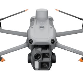
Drone matrice 4e eu/cp.en.00000573 dji
Introducing the DJI Matrice 4 Series, a new compact and intelligent multi-sensor flagship drone series for enterprise industries. The series includes Matrice 4T and Matrice 4E, each equipped with advanced features such as smart detection and measurement with laser range finder. Flight operations are now safer and more reliable with significantly enhanced sensing capabilities. The accessories for the Matrice 4 series have also been significantly upgraded. The Matrice 4T is suitable for a wide range of industries, including electricity, emergency response, public safety, and forestry conservation. The Matrice 4E is designed for geospatial applications such as surveying and mapping, construction, and mining. A new era in intelligent aerial operations begins now.
Two Models, Countless Applications
Intelligent Operations
Smarter Operations
The built-in model can detect vehicles, vessels, and subjects during search and rescue operations or routine flights. It also supports switching to other models, enabling the expansion of application scenarios. Additionally, it supports high-res grid photos and features powerful tracking capabilities.Laser Range Finder, Precise Measurement
The laser range finder enables real-time precise measurement. Through simple operations such as pin point, line drawing, and area calculation, it can complete tasks like marking target locations for inspection purposes or calculating the area of a wildfire. Additionally, users can share info via the DJI Pilot QR code or FlightHub 2 with relevant personnel to enhance collaboration and workflow efficiency.Observation Range Recording
DJI Pilot 2 can highlight the center position of the camera frame and ground area observed. It can display the surveyed area on the map, making it especially useful for patrols, and rescue operations in mountainous terrain without clear landmarks.Efficient Flight, Intelligent Operations
Cruise
Activate cruise control mode to pilot the drone in a specific direction without constantly pressing the control sticks, making long-distance flights easier.FlyTo
In emergencies or disasters, the drone can automatically adjust its flight path and speed based on the surrounding environment, allowing it to reach a designated location without manual adjustments.Smart Track
Smart Track allows for precise subject positioning and automatic zoom adjustments, allowing you to switch between subjects easily. It can automatically reacquire a subject even if obscured briefly.POI
POI enables continuous observation and 3D modeling of buildings while flying around a designated area, greatly enhancing the efficiency of fixed-point observation and modeling tasks.Excel In Low-Light Environments
Night Scene Mode
The Matrice 4 series has received a significant night mode upgrade. Its Full-Color night vision now supports three modes and includes two levels of enhanced noise reduction. Equipped with an IR Cut Filter and NIR auxiliary light, it effortlessly overcomes the challenges of darkness, ensuring search and rescue subjects clearly visible.Smart Low-Light Photo
Smart Low-Light Photo
The Matrice 4 series cameras feature larger apertures and intelligent low-light capabilities, significantly enhancing performance and improving operations during dusk and nighttime.NIR Auxiliary Light
NIR Auxiliary Light
The Matrice 4T features new NIR illumination hardware, enabling lighting distances of up to 100 meters. This ensures clear visibility of objects in dark environments, making it ideal for applications like wildlife protection.Thermal Imaging
Thermal Imaging
The Matrice 4T supports infrared High-Res Mode, with image resolutions up to 1280 × 1024. It also offers Ultra-High Resolution, revealing small temperature details for various operations. Each device undergoes temperature accuracy calibration and utilizes an onboard temperature sensor to provide real-time temperature measurements.Low-Light Fisheye Omnidirectional Sensing
Low-Light Fisheye Omnidirectional Sensing
The Matrice 4 series has six high-definition low-light fisheye vision sensors, significantly enhancing visual low-light positioning and obstacle avoidance capabilities. This allows for automatic obstacle avoidance, intelligent rerouting, and safe return in urban low-light environments.Crystal Clear Vision: Unveil the Details
Capture Every Detail at A Distance
Enhanced Medium Telephoto
The Matrice 4 series is equipped with a medium tele camera, expanding its capabilities for medium-range inspection tasks. During power line or bridge inspections, it can detect screws and cracks from a distance of 10 meters and clearly read instrument data at substations.Super Resolution Telephoto
The tele camera of the Matrice 4 series has significantly improved clarity, featuring 48 MP resolution, capable of capturing incredibly details from signs up to 250 meters away. Additionally, the Matrice 4T is equipped with an IR-Cut Filter, ensuring 24/7 operations.Foreground Stabilization for Telephoto Imagery
The upgraded telephoto stabilization makes foreground subjects stable and clear during telephoto shooting at 10x zoom or higher. In scenarios such as public safety and inspections, subject details are clearly visible.Electronic Dehazing, Clear as Ever
In conditions such as smog or atmospheric humidity, Electronic Dehazing supports three modes (Low, Medium, High) to improve the imaging clarity of the Matrice 4 series to match different operational environments and requirements.Precision Mapping, Time-Saving and Effortless
Rapid 0.5-Second Interval Shooting
The Matrice 4E wide-angle camera supports rapid 0.5-second interval shooting in both orthophoto and oblique photography modes, enabling high-speed aerial surveying from multiple angles. Additionally, the mapping flight speed can reach up to 21 meters per second, significantly enhancing work efficiency.Multi-Directional Capture, Efficiency Multiplied
5-Directional Oblique Capture
The Matrice 4 series supports a new 5-directional oblique capture. The gimbal can intelligently rotate and shoot at multiple angles based on the survey area, achieving the effect of multiple shots in a single flight compared to previous models, significantly enhancing the efficiency of small drone oblique photography.3-Directional Ortho Capture [10]
Matrice 4E supports 3-directional ortho capture, enabling lateral capturing while performing ortho collection tasks, which reduces lateral overlap. A single flight can complete mapping operations for an area of 2.8 square kilometers. No additional elevation optimization flight route is required to achieve better elevation accuracy. Combined with new DJI Terra capabilities, it further enhances reconstruction efficiency while ensuring quality.Smart 3D Capture, Precision Modeling
DJI Matrice 4E supports Smart 3D Capture, which allows you to capture and create a rough model on the remote controller. Based on the rough model, it can quickly generate precise mapping routes close to a structures surface, completing detailed measurements and modeling of irregular buildings. It also supports displaying virtual space routes and waypoint photos for smart 3D capture, making it convenient to assess specific routes' flight safety and coverage area.Distortion Correction, Precision Enhancement
Distortion Correction, Precision Enhancement
Distortion Correction 2.0 provides high-precision in-camera distortion correction with residual distortion less than 2 pixels. Each Matrice 4E's wide-angle camera is calibrated before leaving the factory, when used with DJI Terra, it significantly improves reconstruction accuracy.Auto-Generated Surveying Operation Report
Auto-Generated Surveying Operation Report
Upon completion of an operation, DJI Pilot 2 can automatically generate a survey quality report. This report provides comprehensive access to key information such as photo points, RTK status, and photo parameters. If there are any anomalies, additional photos can be taken on-site to avoid repeated trips.Safe Flight, Worry-Free Operation
Fusion Positioning, Safe Return-to-Home
The Matrice 4 series comes with an integrated DJI RTK module which supports the extended L5 frequency band and features GNSS+Vision Fusion Positioning and Navigation System. It allows for the return-to-home point to be updated through visual positioning, allowing for rapid takeoff within 15 seconds. Even without GNSS signals, it can complete the return-to-home process, effectively overcoming signal obstructions and interference commonly found in urban environments.Intelligent Guidance, Unobstructed Flight
When the DJI RC Plus 2 Enterprise remote controller is connected to the internet, it can load terrain elevation maps and preload detailed maps. This enables automatic path planning for obstacle avoidance, effectively managing scenarios such as flying at night or through mountainous areas, ensuring the safety of flight operations. The drone has a 5-directional vision assist view system along with downward vision, which aids in providing comprehensive visibility for enhanced protection.Achieve New Heights in Video Transmission
The O4 Enterprise video transmission system sets a new industry standard for challenging environments. Thanks to the 8-antenna system in the Matrice 4 Series and the high-gain antenna in the remote controller, you can achieve up to 25 kilometers in transmission range. Furthermore, the system improves image transmission with a download bandwidth of 20MB/s, more than double the bitrate of the Mavic 3 Enterprise Series, ensuring more precise and stable images of route uploads and material downloads.The Matrice 4 series supports an optional DJI Cellular Dongle 2. By utilizing 4G image transmission in conjunction with the aircraft's antennas, signal stability is further enhanced.
Accessory Upgrades, Performance Leap
Gimbal-Following Spotlight
The DJI AL1 SpotLight can illuminate subjects up to 100 meters away, and features two modes, Always-On and Strobe. It can connect with the gimbal, enabling it to follow the camera's movements to ensure the illuminated area aligns with the camera's view. Additionally, the spotlights can focus on a single object or offer a wide field of view (FOV) which illuminates up larger areas.Real-Time Voice Speaker
The DJI AS1 Speaker offers impressive sound power and extensive range. It has a broadcast range of up to 300 meters and can produce a volume of up to 114 decibels at a distance of 1 meter. It supports recorded messages, media imports, and text-to-speech conversion. Additionally, it features real-time broadcasting and echo suppression, enhancing the efficiency and flexibility of emergency search-and-rescue operations.Integrated Broadcasting and Lighting
The spotlight and speaker can function independently or together, addressing various operational scenarios.High-Precision D-RTK 3 Multifunctional Station
The D-RTK 3 Multifunctional Station can serve as a base station to provide centimeter-level positioning for multiple drones simultaneously or extend the operational range of drones in relay station mode*. Additionally, the new Rover Station Mode, combined with the DJI Enterprise app and DJI Terra, provides a comprehensive solution for high-precision aerial surveying applications, ensuring a secure and accurate operation.DJI RC Plus 2 Enterprise
DJI RC Plus 2 Enterprise remote controller features a new high-brightness screen that remains clearly visible even in direct sunlight. It has an IP54 protection rating and can operate in temperatures ranging from -4°F to 122°F (-20°C to 50°C). Using the O4 Enterprise video transmission system, it features a built-in high-gain antenna array, providing strong performance. It also supports O4 Enterprise and 4G hybrid transmission solutions, ensuring stable and smooth video transmission in urban high-rise areas and mountainous environments.DJI Cellular Dongle 2 [14]
The DJI Cellular Dongle 2 offers 4G network video transmission and can work together with the O4 Enterprise video transmission system, ensuring safe flights in complex environments. Additionally, it provides mobile network connectivity for the remote controller.DJI Power 1000
DJI Power 1000 can provide up to 200W fast charging for Matrice 4 Series intelligent batteries, fully charging one battery in 48 minutes. It also offers 2200W AC output, ensuring a reliable and stable power supply for outdoor operations. Additionally, it can be paired with the DJI Power 1kW car charger, allowing for 1kW fast charging, supporting outdoor operations with continuous power and uninterrupted journeys.Software Designed for Industries
DJI Pilot 2
DJI Pilot 2 interface has been comprehensively updated, featuring a customizable intelligent function toolbar and support for various types of flight routes. Additionally, it includes virtual space models and route preview functions, making operations more convenient and efficient. It can connect with FlightHub 2 to enhance drone control operations and facilitate cloud information sharing, therefor reducing the workload of frontline pilots.DJI FlightHub 2
Specifically for the Matrice 4 series aircraft, DJI FlightHub 2 has been upgraded for remote control, allowing a variety of flight route planning functions, including remote takeoff and landing, Smart 3D Capture routes, geometric routes, and slope routes. Operators can control both the payload and the aircraft simultaneously through Live Flight Controls features. During multi-drone operations, operators can synchronize multiple livestreams on a single screen, creating a new efficient air-ground operation experience.DJI Terra
DJI Terra enables high-precision camera distortion correction for the Matrice 4E. It supports free offline PPK processing of visible light images and allows for importing D-RTK 3 data, which enhances reconstruction accuracy. The software provides rich 2D, 3D, and point cloud model data, catering to various applications such as geographic information, emergency response, and construction planning.DJI Modify
DJI Modify provides intelligent 3D mesh and point cloud model editing. When paired with the Matrice 4 Series and DJI Terra, it can create an integrated solution covering aerial surveying, modeling, model repair, and sharing.DTAT 3.0
After completing thermal imaging operations with Matrice 4T, you can use the DTAT 3.0 thermal analysis tool to mark, analyze, and process images, detecting abnormal temperature points.Open Developer Ecosystem
Intelligent Algorithm Developer
Provides the necessary model training tools and third-party developer certification process to access onboard computing capability, helping expand new drone intelligent algorithm application fields.PSDK
E-Port and E-Port Lite encryption authentication ensure secure and worry-free payloads, enabling the Matrice 4 Series to have broader application scenarios.MSDK
Mobile SDK 5 simplifies the development of apps to control the Matrice 4 Series. Mobile SDK 5 is fully open source and comes with production code samples of core DJI Pilot 2 modules, ensuring its reliability.Cloud API
With DJI Pilot 2's built-in Cloud API (MQTT-based protocol) you can directly connect the Matrice 4 Series to third-party cloud platforms. Access the drone's hardware, video live-stream, and photo data without having to develop an app.DJI Terra API
With the DJI Terra API, users can integrate its powerful mapping capabilities into their own platforms, achieving automated 2D and 3D reconstructions. Additionally, users can customize photogrammetry workflows as needed, allowing the Matrice 4E's operational results to meet the needs of various industry applications better.User Data Security
Get 1 Year of DJI Care Enterprise Plus or 1 Year of Official Extended Warranty Service for Free
DJI Care Enterprise Plus
Comprehensive Protection | Professional Quality Assurance | Exclusive Service | Service Starts with ActivationFree Repairs
Unlimited number of free repairs within the coverage limit.Flyaway Coverage
1 time/year, worry-free operationCoverage for Your Whole Fleet
Shared limit for maximum protectionFree Shipping
Free Mail-in Repairs, Hassle-Free ServiceExtended Warranty Service
During the service period, the main parts remain covered by the official warranty, bringing longer protection for your product. -
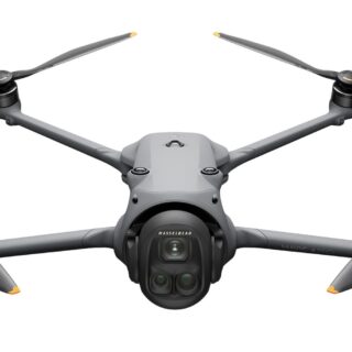
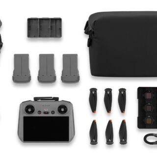
Drone mavic 4 pro 512gb creat./combo cp.ma.00000847 dji
Quadcopter | Grey | Number of rotors 4 rotors | Maximum speed 27 m/s | Maximum operating distance 41000 m | Maximum flight altitude 6000 m | Maximum flight time […]
-
Drone|dji|mavic 4 pro fly more combo|consumer|cp.ma.00000848
Mavic 4 Pro Fly More Combo | Quadcopter | Grey | Number of rotors 4 rotors | Maximum speed 27 m/s | Maximum flight altitude 6000 m | Maximum operating […]
-
Drone|dji|weight 1063 g|max distance 41000 m|max speed 27 m/s|grey|quadcopter|cp.ma.00000849
100MP Hasselblad main camera, large CMOS dual tele cameras, Infinity Gimbal with 360° rotation, 0.1-Lux Nightscape Omnidirectional Obstacle Sensing, O4+ Video Transmission…DJI Mavic 4 Pro is a game-changer, boasting cutting-edge features that redefine our technology and take DJI drone imaging and flight performance to unprecedented levels. This triple-camera flagship drone is set to transform how you create and explore new horizons in aerial photography.
Triple-Camera Imaging System
Master Every Angle
Introducing the advanced triple-camera system, where each lens excels, capturing exceptional images ranging from expansive wide-angle landscapes to detailed telephoto close-ups. All three cameras boast Dual Native ISO Fusion, which seamlessly blends the benefits of high and low ISO settings to capture stunning details beyond what traditional solutions can achieve. Plus, ignite your creativity with high-resolution RAW stacking of up to 5 frames, along with features like Free Panoramas and Subject Focusing across all cameras.4/3 CMOS Hasselblad Main Camera
The meticulously crafted 4/3 CMOS Hasselblad camera utilizes a brand-new 100MP sensor and supports the renowned Hasselblad Natural Color Solution (HNCS) for exceptional color fidelity. It captures breathtaking 100MP images packed with detail and sharpness, offering unprecedented flexibility in post-processing. The lens has been reengineered to meet the demands of the 100MP sensor, delivering incredible sharpness. A versatile f/2.0 to f/11 aperture allows for clean low-light filming, while also rendering eye-catching 10-ray starburst effects.Medium Tele Camera
Equipped with a 48MP 1/1.3-inch sensor and an f/2.8 aperture, the 70mm medium tele camera delivers enhanced image quality due to its new image processing engine. The 70mm focal length creates compressed perspectives to highlight subjects, ideal for dynamic portraits and car footage with orbital camera movements.Tele Camera
Powered by a 50MP 1/1.5-inch sensor and a wide f/2.8 aperture, the tele camera leverages a specifically optimized gimbal algorithm tailored for its telephoto optics to deliver unparalleled image quality and stability in long-range aerial photography. Its extended reach dramatically reduces depth perception, creating a flattened perspective that isolates subjects with remarkable clarity. Combined with Subject Focusing, capturing breathtaking close-ups becomes effortless. Plus, it captures incredibly detailed Free Panoramas, revealing expansive skylines when zoomed out and intricate cityscapes when zoomed in.Infinity Gimbal: World in Motion
Break creative boundaries with the revolutionary Infinity Gimbal. The innovative gimbal structure allows for full 360° rotation for unprecedented angles. Capture dramatic Dutch angles straight from the camera or reimagine aerial storytelling with fluid, gravity-defying movements.70° Upward Shots for Magnificent Views
Frame mountains and architectural marvels through bold, dynamic perspectives, unlocking endless possibilities for creative compositions.ActiveTrack 360° Just Got More Powerful
ActiveTrack 360° [8] excels even in low-light scenarios like in twilight or under city lights [1], delivering cinematic tracking with enhanced stability. Once tracking begins, Mavic 4 Pro can keep the subject in focus even if the lower half of their body is partially obscured by bushes or if they are standing on a bridge. It also detects vehicles up to 200 meters with directional awareness, delivering professional-grade automotive cinematography.See in All Directions With 0.1-Lux Nightscape Omnidirectional Vision
Mavic 4 Pro is equipped with six high-performance, low-light fisheye sensors and dual processors for high-resolution environmental awareness. It achieves omnidirectional obstacle avoidance at speeds up to 18 m/s even in lighting conditions as low as 0.1 lux, such as environments illuminated only by streetlights. Whether navigating through canyons or urban landscapes with poor satellite signals, this high-performance visual system ensures precise drone positioning. In near-pitch-black environments with brightness below 0.1 lux, it can still use its forward-facing LiDAR to detect obstacles ahead and quickly brake to avoid collisions.51-Min Flight Time
Mavic 4 Pro’s aerodynamic design, efficient propulsion system, and 95Wh battery deliver flight times of up to 51 minutes, top speeds of up to 90 kph, and a range of 41 km (25.4 miles) . Whether you're scouting locations, practicing maneuvers, capturing time-lapse shots, or taking panoramic photos with a telephoto lens, the ample flight time allows you to operate with ease and confidence.DJI O4+ 10-bit HDR Video Transmission
Mavic 4 Pro features the DJI O4+ transmission system, which leverages next-generation proprietary algorithms to unlock the full potential of its hardware. It enables ultra-long-range 10-bit HDR video transmission up to 30 km (18.6 miles)[3] and reduces the likelihood of disconnection in highly interfered environments, such as urban areas. In addition, the O4+ video transmission system is optimized for multi-drone flights, ensuring robust resistance to interference.The DJI RC Pro 2 remote controller, featuring a 7-inch high-brightness rotatable screen, is the ideal companion for the Mavic 4 Pro.
Boost Your Creativity With Efficient Parallel Charging
With the DJI Mavic 240W Power Adapter , the Mavic 4 Pro Parallel Charging Hub fully charges one battery in 51 minutes and can charge three batteries at the same time via the Mini SDC port. The Parallel Charging Hub boosts efficiency by prioritizing the battery with the lowest charge. Once all three batteries reach the same charge level, it switches to parallel charging, fully charging all three batteries in just 90 minutes .By leveraging the batteries' stored power, the Parallel Charging Hub can also transform into a 100W power bank, providing a convenient way to fast-charge phones and laptops on location. Additionally, it features a power accumulation function, which allows you to transfer the remaining power of multiple low-power batteries into the battery with the highest remaining power.
Up to 512GB Onboard Storage
DJI Mavic 4 Pro standard version comes with 64GB onboard storage , so you can start capturing right away without an external memory card. Mavic 4 Pro 512GB in the Creator Combo features 512GB high-speed onboard storage , supporting high-spec ALL-I 4:2:2 encoded video recording and time-lapse photography with intervals as short as 1 second, ensuring you're always ready to capture your next masterpiece.100MP RAWs Transferred in Seconds!
With QuickTransfer, there's no need to take the drone and controller out of your bag to transfer footage. Simply wake Mavic 4 Pro remotely via the DJI Fly app, and transfer files at speeds up to 80MB/s[18] over Wi-Fi 6. Even when switching apps, the DJI Fly app continues downloading smoothly in the background. To easily transfer footage to a computer, simply connect the drone to a computer via a compatible USB cable without needing to power on the drone. -
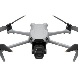
Drone|dji|air 3s fly more combo (dji rc 2)|consumer|cp.ma.00000816
Air 3S Fly More Combo (DJI RC 2) | Quadcopter | Grey | Foldable Yes | Drone class C1 | Number of rotors 4 rotors | Maximum speed 27 m/s […]
-
Drone|dji|weight 724 g|max distance 32000 m|max speed 27 m/s|foldable yes|grey|quadcopter|cp.ma.00000814
Quadcopter | Grey | Foldable Yes | Number of rotors 4 rotors | Maximum speed 27 m/s | Maximum flight altitude 6000 m | Maximum operating distance 32000 m | […]
-
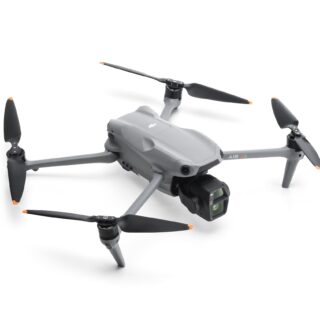
Drone|dji|mini 5 pro fly more combo (dji rc 2)|consumer|cp.ma.00000894
Mini 5 Pro Fly More Combo (DJI RC 2) | Quadcopter | Black/Grey | Foldable Yes | Number of rotors 4 rotors | Maximum speed 18 m/s | Maximum flight […]
-
Drone mini 5 pro fly more comb/rc-n3 cp.ma.00000876 dji
Quadcopter | Black/Grey | Foldable Yes | Number of rotors 4 rotors | Maximum speed 18 m/s | Maximum operating distance 21000 m | Maximum flight altitude 6000 m | […]
-
Drone mini 5 pro/cp.ma.00000838 dji
Quadcopter | Black/Grey | Foldable Yes | Number of rotors 4 rotors | Maximum speed 18 m/s | Maximum operating distance 21000 m | Maximum flight altitude 6000 m | […]
Droonimaailm.ee - Suurima kogemusega drooniekspert Eestis | Tel: 68 78 770

