


DJI Terra – Agriculture Version, 1 Year
Capture, analyze and visualize your environment with DJI Terra – an intuitive, PC-based mapping software developed to help industry professionals transform real-world scenarios into digital assets. *
- Flight Planning: simply select an area on the map to create flight paths and automate complex missions.
- Waypoint Mission Planning: create efficient flight paths with waypoint actions, adjust parameters such as altitude, speed, and gimbal pitch.
- Real-time Mapping: quickly generate a 2D orthomosaic of the selected area in real-time.
- 2D Reconstruction: import images to generate high-resolution RGB orthomosaics and vegetation index maps.
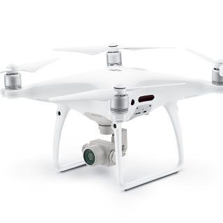
- Supports Phantom 4 Series Drones, including Phantom 4 RTK, Phantom 4 Pro V2.0, Phantom 4 Pro + V2.0, Phantom 4 Pro, Phantom 4 Advanced, Phantom 4.
Make the World Your Digital Asset
Capture, analyze and visualize your environment with DJI Terra – an easy to use mapping software developed to help industry professionals transform real-world scenarios into digital assets.
Compatibility
M300 RTK
Phantom4 RTK
